
Leica ULTRA Utility Locator (12 Watt Advanced) For Rent For Discount
Description
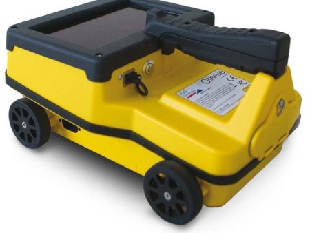
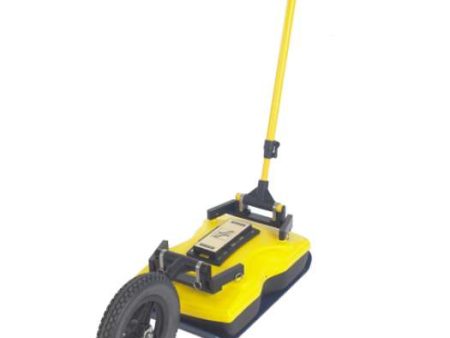
Save time and increase confidence in your results with the Leica ULTRA, an advanced precision utility tracing instrument.
For used and refurbished options, call 1 (770) 674-2489.
- Product Overview
-
- Technical Specifications
-
- Resources
-
- Accessories
-
-
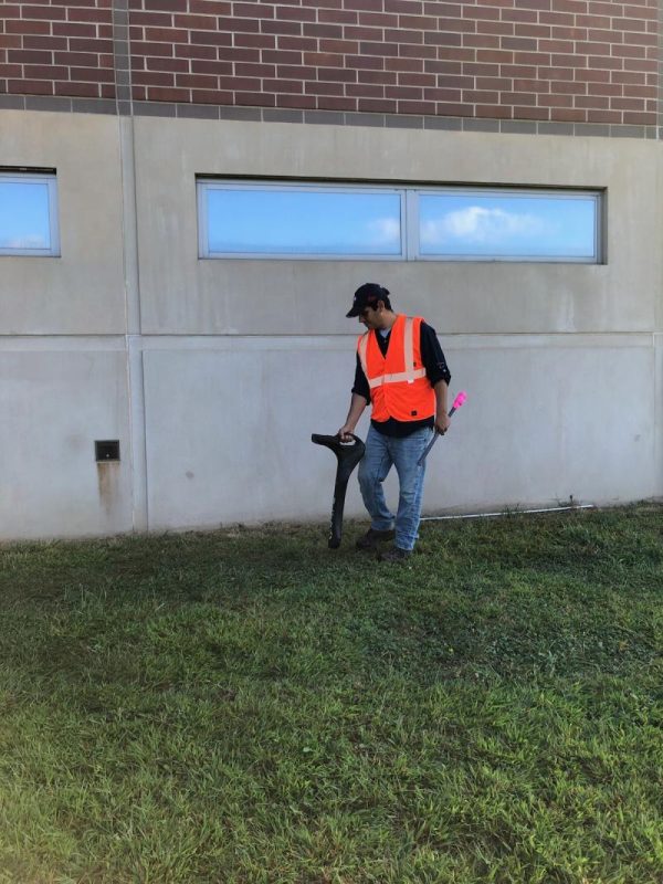
A utility strike occurs every minute in the United States. One of the most cited reasons for strikes is insufficient locating practices. EM locators are the most common tool to reduce the likelihood of damages.
The complexity of underground utility networks is continually increasing, and obtaining precise information on the location of buried utilities has never been more important. The protection of buried assets during excavation work demands accurate mapping and surveying of existing utilities.
This system is optimised specifically for utility tracing
-
Configuration for challenging environments
Optimise the instrument to overcome the most challenging and complex site conditions. The Leica ULTRA locator can be configured for different project environments and has more than 100 programmable operating frequencies available.
-
-
Best frequencies in congested environment
When working in congested environments, the Leica ULTRA incorporates Ambient Interference Measurement (AIM), which digitally analyses the surrounding area for noise and recommends the best frequencies for accurate utility tracing.
-
-
Trace utilities through any obstruction
There will always be an occasion when the utility runs close to or underneath an obstruction. With Offset Measuring, the Leica ULTRA locates the target line if not directly accessible from above. The function uses the available data to estimate the horizontal and vertical (depth) distance.
-
-
Clear operational display
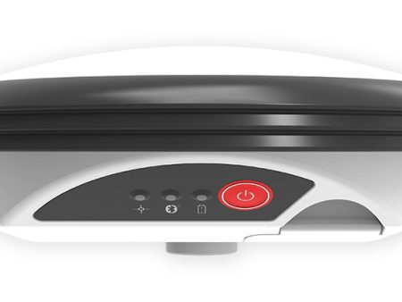
Clear graphical LCD screen, with auto-pinpointing directional arrows. Ensure confident and fast tracing in all operating conditions, day or night, with the large backlit display.
-
-
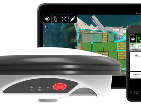
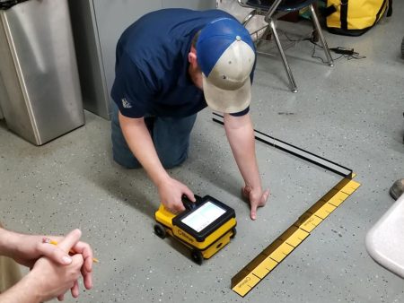
GNSS & GIS integration
True one man, single-step data capture solution for buried utility mapping or surveying applications. Leica ULTRA integrates with GNSS or GIS data capture devices.
-
-
-
Technical Data
Standard | Advanced
Dimension
691 x 325 x 122 mm
(27.2 x 12.8 x 4.75 in)
Weight (including batteries)
2.2 kg (4.8 lb)
PERFORMANCE
Frequency range
50 Hz – 200 kHz
Sensitivity
33 kHz (1 μA at 1 m)
Dynamic range
117 dB
Depth, max
6 m (20 ft)
Locate accuracy
±5% depth
Dynamic overload protection
30 dB (automatic)
Depth accuracy
In line – ±5% to 3 m (±5% to 10 ft)
Sonde – ±5% to 3 m (±5% to 10 ft)
Passive – ±5% to 3 m (±5% to 10 ft)
FEATURES
Enabled frequencies
512 Hz, 3.14 kHz, 8.192 kHz,
32.768 kHz, 83.1 kHz, 200 kHz
Custom frequencies
Up to 100 custom frequencies from 256 Hz – 83 kHz
DE direction enabled
Any frequency from 256 Hz – 10 kHz
Fault-finding DE based
263 Hz
Cathodic protection frequencies
100 Hz, 120 Hz
Power frequencies
50 Hz, 60 HZ, 100 Hz, 120 Hz,
150 Hz, 180 Hz, 450 Hz, 540 Hz
Language support
17 user selectable
Selectable auto shutdown
5, 10, 20 or 30 minutes
PC based configuration
Software updates and configuration can be set by user
High contrast graphical LCD
✔ | ✔
Line direction compass with proportional L R arrow guidance
✔ | ✔
Offset depth
| ✔
AIM
| ✔
Receiver transmitter communications
| ✔
Bluetooth® connectivity
| ✔
ENVIRONMENTAL
Operating temperature
-20 °C – 50 °C (-4 °F – 122 °F)
Storage temperature
-32 °C – 70 °C (-25 °F – 158 °F)
Environmental protection
IP65
BATTERY
Batteries
2 D-cell (LR20)
Battery life (max)
30 hrs continuous
70 hrs intermittent
Transmitters
Technical Data
5 Watt | 12 Watt | Advanced
Dimension
254 x 305 x 91 mm
(10 x 12 x 7.75 in)
Weight (including batteries)
3.4 kg (7.7 lb)
PERFORMANCE
Frequency range
256 Hz – 200 kHz
Output power
5 Watt | 12 Watt | 12 Watt
Current, max
500 mA
Voltage, max
65V rms
FEATURES
Enabled frequencies
512 Hz, 3.14 kHz, 8.192 kHz,
32.768 kHz, 83.1 kHz, 200 kHz
Custom frequencies
Up to 100 custom frequencies from 256 Hz – 83 kHz
Language support
17 user selectable
Induction
16 induction frequencies
PC based configuration
Software updates and configuration can be set by user
Fault-finding DE based
263 Hz
Multimeter functions
Watts, currents, ohms and volts
High contrast graphical LCD
✔ | ✔ | ✔
External 12V power connection
| | ✔
Dual output
| | ✔
Receiver transmitter communications
| | ✔
ENVIRONMENTAL
Operating temperature
-20 °C to 50 °C (-4 °F to 122 °F)
Storage temperature
-32 °C to 70 °C (-25 °F to 158 °F)
Environmental protection
IP65
BATTERY
Batteries
10 D-Cell (LR20)
or Li-Ion battery pack (optional)
Battery life (max)
100 hrs with alkaline
80 hrs with Li-Ion battery pack
Offset depth
Measures horizontal and vertical distance to the line
Ambient Interference Measurement (AIM)
Measures interference and recommends best frequency
Receiver Transmitter communications
Remotely control transmitter frequency, power level and more
Bluetooth®
Wireless connectivity to GIS field PC, GNSS receiver
Dual output
Remotely select active output (must have optional dual output leads)
Induction frequencies
8.01 kHz, 8.192 kHz, 8.44 kHz, 9.82 kHz, 29.4 kHz, 32.8 kHz, 39 kHz, 44.6 kHz, 65.5 kHz, 78.1 kHz, 80.4 kHz, 82.5 kHz, 83.1 kHz, 89 kHz, 131 kHz, 200 kHz
-
-
Links
-
- List
-
Additional Information
Title
Default Title
Related products
Leica GG04 Plus on Sale
Original price was: $8,850.00.$2,655.00Current price is: $2,655.00.
IDS Georadar Stream UP GPR For Rent Supply
Original price was: $222,000.00.$66,600.00Current price is: $66,600.00.
IDS Cthrue For Rent For Discount
Original price was: $13,600.00.$4,080.00Current price is: $4,080.00.
Leica DD130 Cable Avoidance Tool for Rent Hot on Sale
Original price was: $3,639.00.$1,091.70Current price is: $1,091.70.
Sensors & Software Noggin GPR For Rent Fashion
Original price was: $29,100.00.$8,730.00Current price is: $8,730.00.

peakusflow.shop © 2025 All Rights Reserved
-
-
Select the fields to be shown. Others will be hidden. Drag and drop to rearrange the order.
- Image
- SKU
- Rating
- Price
- Stock
- Description
- Weight
- Dimensions
- Additional information
- Add to cart
-
A utility strike occurs every minute in the United States. One of the most cited reasons for strikes is insufficient locating practices. EM locators are the most common tool to reduce the likelihood of damages.
The complexity of underground utility networks is continually increasing, and obtaining precise information on the location of buried utilities has never been more important. The protection of buried assets during excavation work demands accurate mapping and surveying of existing utilities.
This system is optimised specifically for utility tracing
-
Configuration for challenging environments
Optimise the instrument to overcome the most challenging and complex site conditions. The Leica ULTRA locator can be configured for different project environments and has more than 100 programmable operating frequencies available.- Best frequencies in congested environment
When working in congested environments, the Leica ULTRA incorporates Ambient Interference Measurement (AIM), which digitally analyses the surrounding area for noise and recommends the best frequencies for accurate utility tracing.- Trace utilities through any obstruction
There will always be an occasion when the utility runs close to or underneath an obstruction. With Offset Measuring, the Leica ULTRA locates the target line if not directly accessible from above. The function uses the available data to estimate the horizontal and vertical (depth) distance.- Clear operational display
Clear graphical LCD screen, with auto-pinpointing directional arrows. Ensure confident and fast tracing in all operating conditions, day or night, with the large backlit display.- GNSS & GIS integration
True one man, single-step data capture solution for buried utility mapping or surveying applications. Leica ULTRA integrates with GNSS or GIS data capture devices.-
Technical Data
Standard | Advanced
Dimension
691 x 325 x 122 mm
(27.2 x 12.8 x 4.75 in)Weight (including batteries)
2.2 kg (4.8 lb)
PERFORMANCE
Frequency range
50 Hz – 200 kHz
Sensitivity
33 kHz (1 μA at 1 m)
Dynamic range
117 dB
Depth, max
6 m (20 ft)
Locate accuracy
±5% depth
Dynamic overload protection
30 dB (automatic)
Depth accuracy
In line – ±5% to 3 m (±5% to 10 ft)
Sonde – ±5% to 3 m (±5% to 10 ft)
Passive – ±5% to 3 m (±5% to 10 ft)FEATURES
Enabled frequencies
512 Hz, 3.14 kHz, 8.192 kHz,
32.768 kHz, 83.1 kHz, 200 kHzCustom frequencies
Up to 100 custom frequencies from 256 Hz – 83 kHz
DE direction enabled
Any frequency from 256 Hz – 10 kHz
Fault-finding DE based
263 Hz
Cathodic protection frequencies
100 Hz, 120 Hz
Power frequencies
50 Hz, 60 HZ, 100 Hz, 120 Hz,
150 Hz, 180 Hz, 450 Hz, 540 HzLanguage support
17 user selectable
Selectable auto shutdown
5, 10, 20 or 30 minutes
PC based configuration
Software updates and configuration can be set by user
High contrast graphical LCD
✔ | ✔
Line direction compass with proportional L R arrow guidance
✔ | ✔
Offset depth
| ✔
AIM
| ✔
Receiver transmitter communications
| ✔
Bluetooth® connectivity
| ✔
ENVIRONMENTAL
Operating temperature
-20 °C – 50 °C (-4 °F – 122 °F)
Storage temperature
-32 °C – 70 °C (-25 °F – 158 °F)
Environmental protection
IP65
BATTERY
Batteries
2 D-cell (LR20)
Battery life (max)
30 hrs continuous
70 hrs intermittent
Transmitters
Technical Data
5 Watt | 12 Watt | Advanced
Dimension
254 x 305 x 91 mm
(10 x 12 x 7.75 in)Weight (including batteries)
3.4 kg (7.7 lb)
PERFORMANCE
Frequency range
256 Hz – 200 kHz
Output power
5 Watt | 12 Watt | 12 Watt
Current, max
500 mA
Voltage, max
65V rms
FEATURES
Enabled frequencies
512 Hz, 3.14 kHz, 8.192 kHz,
32.768 kHz, 83.1 kHz, 200 kHzCustom frequencies
Up to 100 custom frequencies from 256 Hz – 83 kHz
Language support
17 user selectable
Induction
16 induction frequencies
PC based configuration
Software updates and configuration can be set by user
Fault-finding DE based
263 Hz
Multimeter functions
Watts, currents, ohms and volts
High contrast graphical LCD
✔ | ✔ | ✔
External 12V power connection
| | ✔
Dual output
| | ✔
Receiver transmitter communications
| | ✔
ENVIRONMENTAL
Operating temperature
-20 °C to 50 °C (-4 °F to 122 °F)
Storage temperature
-32 °C to 70 °C (-25 °F to 158 °F)
Environmental protection
IP65
BATTERY
Batteries
10 D-Cell (LR20)
or Li-Ion battery pack (optional)Battery life (max)
100 hrs with alkaline
80 hrs with Li-Ion battery packOffset depth
Measures horizontal and vertical distance to the lineAmbient Interference Measurement (AIM)
Measures interference and recommends best frequencyReceiver Transmitter communications
Remotely control transmitter frequency, power level and moreBluetooth®
Wireless connectivity to GIS field PC, GNSS receiverDual output
Remotely select active output (must have optional dual output leads)Induction frequencies
8.01 kHz, 8.192 kHz, 8.44 kHz, 9.82 kHz, 29.4 kHz, 32.8 kHz, 39 kHz, 44.6 kHz, 65.5 kHz, 78.1 kHz, 80.4 kHz, 82.5 kHz, 83.1 kHz, 89 kHz, 131 kHz, 200 kHzLinks
- List
- Image
- SKU
- Rating
- Price
- Stock
- Description
- Weight
- Dimensions
- Additional information
- Add to cart
Additional Information
Title Default Title
Related products
Leica GG04 Plus on Sale
Original price was: $8,850.00.$2,655.00Current price is: $2,655.00.IDS Georadar Stream UP GPR For Rent Supply
Original price was: $222,000.00.$66,600.00Current price is: $66,600.00.IDS Cthrue For Rent For Discount
Original price was: $13,600.00.$4,080.00Current price is: $4,080.00.Leica DD130 Cable Avoidance Tool for Rent Hot on Sale
Original price was: $3,639.00.$1,091.70Current price is: $1,091.70.Sensors & Software Noggin GPR For Rent Fashion
Original price was: $29,100.00.$8,730.00Current price is: $8,730.00. peakusflow.shop © 2025 All Rights Reserved
-
Configuration for challenging environments